A FLIKR OF BIGFOOT?
This photo showed up on the Flikr account of Jim Rosick - who, according to his profile, is a mechanical engineer from St. Charles, MO.
The photo has since appeared to have been removed from the account.
Click to enlarge
UPDATE 8/17/09:
Recently, I'd posted about this photo on the Oregonbigfoot.com website. It was intriguing as far as Blobsquatches go (at least it didn't need to be circled... *grin*), but I didn't have a lot of information about it. Yesterday, I received the following email:
Autumn, Please acknowledge receipt of this message by return email. I realize I do not have your direct email address and hope this reaches you. See this link for a brief video summary of our organization's investigation into the James Rosick photo posted on your main web page.
The Rosicks cooperated with our investigation by sending us a high definition enlargement of the photograph in question, its negative and the proof sheet showing all of the images on that roll of film. The couple was on their honeymoon and as Green Bay Packer fans had travelled to northeastern WI to attend a televised Monday night home game at Green Bay as part of their honeymoon trip. The photo was taken around midday in November.
Following the guidance provided by Mr. Rosick, I traveled to the same trailhead and hiked back to the vantage point over LaSalle Falls in Florence County, Wisconsin where the photograph in question was taken. My visit was at midafternoon in August. Subsequent enlargement and analysis of a comparison photograph was able to locate the same birch trees and black pegmatite (iron ore) boulder which creates the appearance of a standing figure in the background of the photograph in question.
We are confident that the "figure" in the photograph is only a chance configuration of branches and foliage against the dark background of the native rock at this location. Upon reaching this conclusion, Mr. Rosick gave us permission to publish our findings (documented in the video clip) on the condition that we removed his image from the original photo in question. Let me know if I can be of any further assistance.
David Gay (escAPEe) Research Director, Squatchdetective organization http://escapees-hideaway.blogspot.com/
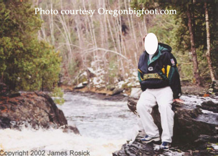
Here is the photo in question:
If you follow this link, you can view a brief video about the photograph and the comparison shot. My first impression was that it was difficult to discern anything from the comparison shot, given that it appears to have been taken at a very different time of year due to the abundance of leaves on the tree. I see a "dark" area in the background behind the leaves, but I cannot tell from the brief explanation and flashes of "comparison points" that it is, in fact, responsible. In order to confirm in my own mind that the dark rocks indeed present the same shape that would make it responsible for the "subject" in the original photo, I'd like to see a photograph taken from the same location during the same time of year. (I guess I'm just a stickler when it comes to comparison photos... exact angle, time of year and time of day, even similar weather conditions if possible, are imperative if you're planning to reproduce and definitively discern what is or is not in a photograph! :))
A gigantic thanks to David Gay for sending this along for our perusal!
UPDATE 8/19/09: David emailed me again and sent along the following:
Report of the Investigation conducted on the Rapid Pines, Wisconsin Photograph
2002
Investigation date: August 23rd, 2006
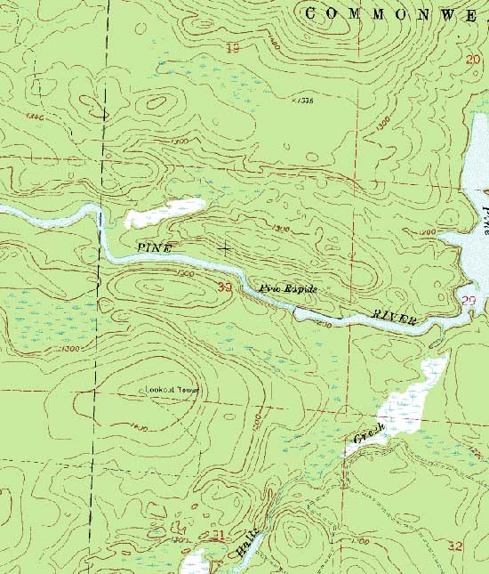
SUMMARY BACKGROUND ON THE ORIGINAL PHOTOGRAPH: The photograph in question (film shot #9 from a 35mm roll of 24 pictures) was taken in the early afternoon of 6-Nov-2002 by newlywed Mrs. XXXXXX during their honeymoon trip. It shows Mr. XXXXXX of St. Peters, Missouri standing at the edge of rapids above a waterfall and was the only picture the couple took showing that scene. The temperatures were in the 30s, skies overcast and snow flurries were forecast in the afternoon. Traces of snow remaining on the ground can be seen in the series of photographs taken at the location.
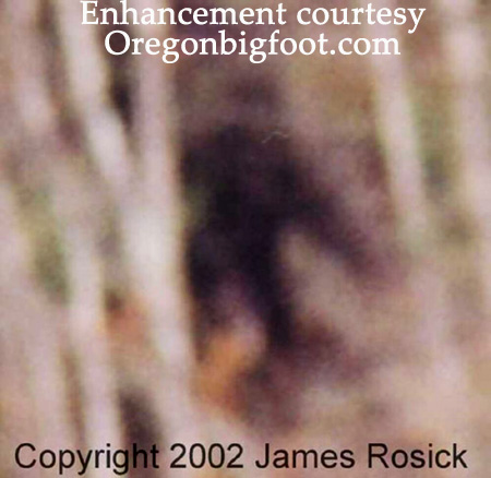
Mr. XXXXXX provided GPS coordinates which pinpoint the scene in the photograph as being at LaSalle Falls on the Pine River in Florence County, Wisconsin. The background scenery of the photograph in question looks east showing the river curving to the left in a wooded valley with no horizon or sky visible in the frame. Above and to the left (his right) shoulder in the photograph, a suspicious dark figure is clearly seen in both an 8" by 10" enlargment of the photograph and the original negative (copies of both were obtained by the Squatchdetective Organization from Mr. XXXXXX in April 2006).
A copy of the index print showing all other pictures taken on that roll of film was also obtained in April 2006. The label on the index print shows that the film was developed at a Costco pharmacy in St. Peters, Missouri. The first 2 shots on the film show the pictures each took of the other along the 1-mile trail between the parking lot trailhead and the falls, shot #3 shows the rapids upriver of the falls, shots 4, 5, 6, 7 and 8 were taken of Mrs. XXXXXX by Mr. XXXXXX facing west with the upstream rapids as the background and shot #9 was taken by Mrs. XXXXXX of Mr. XXXXXX facing east with the downstream scenery beyond the falls as a background (this is the only shot showing a suspicious figure).
Apparently, Mr. and Mrs. XXXXXX remained in their respective positions facing each other alongside the rapids above LaSalle Falls for a long enough time for Mr. XXXXXX to take the 5 pictures of Mrs. XXXXXX, then he handed the camera to Mrs. XXXXXX and she took the photograph in question of Mr. XXXXXX. Shot numbers 10 through 15 show details of the river, rocks and trees typical of the vicinity. The index print helps corroborate the story of the couple's hike on Wednesday, 6-Nov-2002 as part of their honeymoon vacation trip. The honeymoon trip was scheduled to include their attendance at a televised home game for the Green Bay Packers on Monday night, 4-Nov-2002. It is Mr. XXXXXX's testimony that anything resembling the background figure visible in shot #9 was not heard or seen anytime while they were visiting the falls. The suspicious figure was only first noticed quite some time after the film was developed while they were looking through their honeymoon pictures at home. Mr. XXXXXX eventually posted the photograph on his Flickr public photo album in February 2004 as a conversation piece to be viewed by friends and family members with the caption, "Is this a Sasquatch?" Until being discovered by a Squatch Detective investigator, other people who found and saw the on-line photograph in question apparently assumed it was a PhotoShop gag.
I discovered the photograph in question in March 2006. I tracked Mr. XXXXXX down using the email address he listed in his profile for the Flickr web site and initiated a series of email correspondence with Mr. XXXXXX. During the course of this correspondence, I learned the background story behind the photograph in question and earned the couple's trust. Per our request, the couple uncovered the materials we needed to launch an investigation (primarily the photo negative and other shots taken before and after the photograph in question).
Mr. XXXXXX later informed the Squatchdetective Organization that I was the first investigator to contact him regarding the photograph. He frequently mentioned that he didn't want the photograph to attract publicity to his family. In fact, shortly after he released copies of an uncompressed 8" by 10" enlargement of the photograph in question, the negative and the index print to us, Mr. XXXXXX removed the photo from his Flickr public photo album in an apparent move to avoid attracting any further public attention. Abiding by Mr. XXXXXX's wishes, the version of the photograph in question as it appears posted on the Squatch Detective web site is modified only to remove the image of Mr. XXXXXX himself.
TRAVELING TO FLORENCE COUNTY, WISCONSIN: On August 23, prior to hiking into LaSalle Falls, I visited the Wild Rivers Interpretive Center [WRIC] in Florence, Wisconsin. I found a mural painting showing an artist's conception of what LaSalle Falls might look like from the bottom of the Pine River Gorge covering the main wall opposite the entrance at the WRIC. With its 20+ foot descent into the gorge bordered by vertical cliffs nearly 100-feet high, LaSalle Falls is the most impressive natural feature in Florence County. However when I asked the staff if they had any photographs of LaSalle Falls or the Pine River gorge, they said they only had souvenir photograph postcards of the mural painting at the WRIC. They had no photographs of the falls or the gorge. Before leaving the WRIC, I made sure I had their detailed county map showing the 2.5-mile logging road and 1-mile hiking trail to the falls.
My family and I reached the trail head parking lot at 4pm. We hiked at the walking speed for my 8-yr. old daughter and it took 30 minutes to each the portage trail used by canoeists to bypass the falls and rapids in the gorge. We explored the vicinity and took photographs between 4:30pm and 5:30pm, hiked back out to the car by 6pm.
GEOGRAPHY AND TOPOGRAPHY OF THE FALLS, RIVER AND VICINITY: In 1969, the Pine and Popple Rivers in Florence County, Wisconsin were designated as Wild and Scenic River Corridors with special protected status. In the years that followed this designation, the state government purchased the land extending 1 mile on each side of the rivers to preserve the wilderness and scenic beauty of the river valleys and adjacent woodlands.
The bedrock exposed in the Pine River Gorge in Florence County, Wisconsin is an unusual grey volcanic granite known as pegmatite that would have formed as an underground intrusion of magma at lower temperatures. It contains many impurities and minerals that erode on exposure, leaving the rock with crumbling, pock-marked appearance. [Google the words, pegmatite + Florence + County + Wisconsin, for links to numerous scientific articles on this region's unusual bedrock].
The Pine River narrows and descends as rapids for some 50 feet upstream of LaSalle Falls before it vertically plummets over 20 feet into the Pine River Gorge. It then churns and winds through the gorge as a Class III whitewater rapids for nearly a half mile before it widens and reaches the level maintained by the Pine River Dam holding back the large reservoir known as the Pine River Flowage. Before the dam was built, the rapids continued for several more miles.
The fractured granite walls on each side of the gorge are nearly 100-feet high at their tallest points.
The American Whitewater organization described LaSalle Falls as follows, "This section of the Pine is quiet water until one comes to the approach rapid to LaSalle Falls, after a bend to the right. Before the current picks up speed and the river appears to 'drop off' ahead, get out and portage on the right. LaSalle Falls is a 20' high dome-style falls and, while it has been run, should be treated with caution." Riverfacts.com states, "This section of Pine River (from LaSalle Falls to Power Dam Road) in Florence County is 2.2 miles long and has been rated as a class II-IV(V) section by American Whitewater. The beautiful scenery of Wisconsin and the beautiful way the water current moves down the stream are reasons enough to come here and paddle. The rapids on Pine River can get absolutely insane, so do double check your helmet and life jacket. Seriously, this section is very deadly." SOURCE: http://www.riverfacts.com/rivers/14307.html.
I found a video clip at http://www.trucurrent.com/wv_lasallefalls.htm produced in April 2005 by TruCurrent Productions, an extreme sports film crew, showing kayakers running LaSalle Falls and the rapids in the gorge. The water flowing over the falls in the video is at its greatest flow rate (spring snow melt). At the end of the video clip, the kayakers are seen climbing up out of the gorge at the downstream end of the portage trail a 1/2 mile below LaSalle Falls. Technically difficult climbing (with ropes and other equipment) would have been required to reach the vantage point of the cameraman showing the kayakers attempting the 20' descent into the gorge.
The Spread Eagle Barrens is an extensive wilderness area east of the Pine River Flowage along the Wisconsin/Michigan border between Florence, Wisconsin and Iron Mountain, Michigan. It is a plain with poor soil covering exposed bedrock that had been eroded by both glaciers and receding floodwaters. Large "potholes" the size of football fields dot the Spread Eagle Barrens landscape where whirlpools at one time had drilled out crater-like recessions in the bedrock. These recesses are now best seen in aerial photographs during the cooler months when they gather pockets of fog or frost.
OBSERVATIONS MADE DURING THE VISIT TO LASALLE FALLS ON 23-AUG-2006: My primary research goals before hiking into the LaSalle Falls vicinity were three-fold: (1) obtain a comparison photograph showing the same scene as the photograph in question, (2) physically reach the spot where the suspicious figure appears to be standing in the photograph in question and (3) obtain another photograph taken from the same vantage point where Mrs. XXXXXX stood that showed me standing where the figure appears to be standing for a size comparison. I am 5' 8" tall and thought the resulting picture could be used to estimate the height of the suspicious figure.
These research goals were secondary to the ultimate objectives of safely conducting my vehicle, my family and myself to and from the falls and make the hike into an enjoyable family outing to a scenic remote location. To make sure I accomplished my research goals, I packed (1) a digital camera (with both optical and digital zoom lens) and a 512 mB Compact Flash storage disk, (2) a pair of FRS walkie-talkies, (3) spare batteries for both the digital camera and walkie-talkies, (4) binoculars, (5) printed copy of the 8" x 10" enlargement of the photograph in question, (6) printed copy of a topographical detail map of the falls vicinity and (7) my copy of Wisconsin's Outdoor Treasuries: A Guide to 150 Natural Destinations by Tim Brewer, a trail guide describing the LaSalle Falls trail (pages 140 and 141). I had a skein of rope and first aid kit in the car, but hoped I wouldn't need them.
The landscape between the blacktop county highway and the trail head parking lot passed through replanted pine trees. We saw numerous econdary logging roads and what we later found out was a grid of horse trails along the 2.5 miles access road. This was also the only place where we saw deer in the woods and heard songbirds. We passed one man in a forestry service pickup truck coming out of the woods as we drove in and found an SUV with Wisconsin plates parked at the trail head. The trail head parking lot was quite large to accomodate vehicles pulling horse trailers. A padlocked gated entrance and map showing 10 miles of marked horse trails wasjust south of the trail head parking lot.
While we were preparing to start the hike, a family of 4 people (2 adults and 2 teenagers),returned from the Falls. When the adults saw the young ages of my children, they repeated several warnings to my wife and I about keeping the kids away from the cliffs. They drove awayand we were didn't see anybody else the rest of the time.
The logging road runs due east and west where it reaches the trail head parking lot and never goes any closer than approx. 1 mile to the Pine River (which also flows east to west through this part of Florence County). This seems to border the Wild and Scenic River Corridor designated for the Pine River. South of the logging road is replanted pine trees. North of the logging road along the 1 mile hiking trail we passed through areas of climax forest (where so little light passes through the overhead canopy that sparse undergrowth surrounds the tree trunks).
Giant pine trees that date back to Wisconsin's historical logging days in the 1800s are seen along the trail. Groves of mixed birch and pine trees were common along the way. In sunnier clearings along the trail, my kids found and picked ripe wild blackberries (which put me on alert to watch for black bear). Nowhere along the hiking trail did I see any sign of deer trails or other paths bisecting the hiking trail. We saw no animals or birds (not even chipmunks), although I did see signs of woodpecker damage on trees and am certain I heard the continuous steady rappings of a woodpecker when we made it back to our car.
At our slow pace, the trail took 30 minutes. Signs were posted both left and right when we reached the vicinity of the Falls and gorge saying the designated trail had ended and extreme caution was advised beyond that point.
We first took the far right trail leading to the downstream end of the portage trail used by canoeists to bypass the Falls and rapids in the gorge. Within 50 yards this trail led to a small clearing on a shelf of rock about 20 feet above river level large enough for a fire ring (probably a lunch spot used by canoeists as this location was not big enough to pitch a tent). This is about 1/2 mile downriver from LaSalle Falls where the Pine River is wide and calm. The actual path down to the river was quite steep. The southern bank of the Pine River at the put-in location was a pile of broken rock and small boulders.
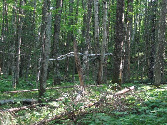
As we walked away from the southern end of the portage trail, I looked into the forest downstream and saw an unusual placement of birch logs wedged horizontally about 10 feet above the ground among the pine trees. This was about 50 feet away from the trail, so I zoomed in to take the photograph. The forest floor is a snarl of fallen pine branches. The bright white bark of the birch logs is in high contrast to the surrounding trees as there were no such birch trees in the immediate vicinity.
*** THEORETICAL EXPLANATION: Were these birch branches placed in that location as a boundary marker? *** Next we walked toward the gorge on the left fork of the south portage trail. A trail sign labels this as leading to a bluff overlook. This too was a short walk of less than 50 yards. All it leads to is the edge of a cliff between two craigs, left and right, where you can look down and see the edge of the rapids about 40 or 50 feet down. I saw a possible trail leading up the craig on the right (east) which I followed about 20 steps to a dead end. The dead end on top of the craig was surrounded by fallen branches making it impossible to see anything from this vantage point. About 5 steps back down toward the bluff overlook, I found a pile of dark manure or scat along the trail. I didn't see it on my way up the trail, but I guess I was looking down better as I descended from the craig (as an old joke would have said, "It's a good thing I didn't step in it."). The scat was weathered and spread out, covering an area the size of 2 dinner plates. It's dark brown appearance was in stark contrast to the sandy pale tan soil and grey exposed rock. It appeared to contain wood fibers the thickness of toothpicks embedded in it. As I wasn't prepared to collect a scat sample, I simply took the photograph and moved on.
*** THEORETICAL EXPLANATION: Although at my height of 5'8" I couldn't see anything from the cul-de-sac at the top of the craig, someone much taller may use this spot as a lookout location. Possible alternate escape routes were available if one was willing to go over the edge of the cliff. The scat may have been from a black bear-- I'll admit that I don't know scat or whether bear chew on wood. *** We next returned to the main junction in the portage trail and headed upstream toward the falls. This turned out to be a much longer hike than than the downstream (east) trails. About half the distance along this stretch of the trail (an estimated 1/4 mile downstream from the falls), we found a rocky clearing that led to the edge of the gorge. This was the best bluff overlook we found looking down at the rapids in the gorge. However, it overlooked a bend in the river and we could not see upstream to where the falls were located nor could we see downstream to the eastern end of the portage trail. The dense woods overhanging the gorge and the inaccessible shoreline of the rapids along the Pine River can be seen in this photograph. As we hiked west from this point, we heard the sound of LaSalle Falls growing louder and we knew we were getting close. The portage trail was set well back in the woods away from the rocky cliffs and we had no further scenic overlooks along the western 1/4 mile of the hike.
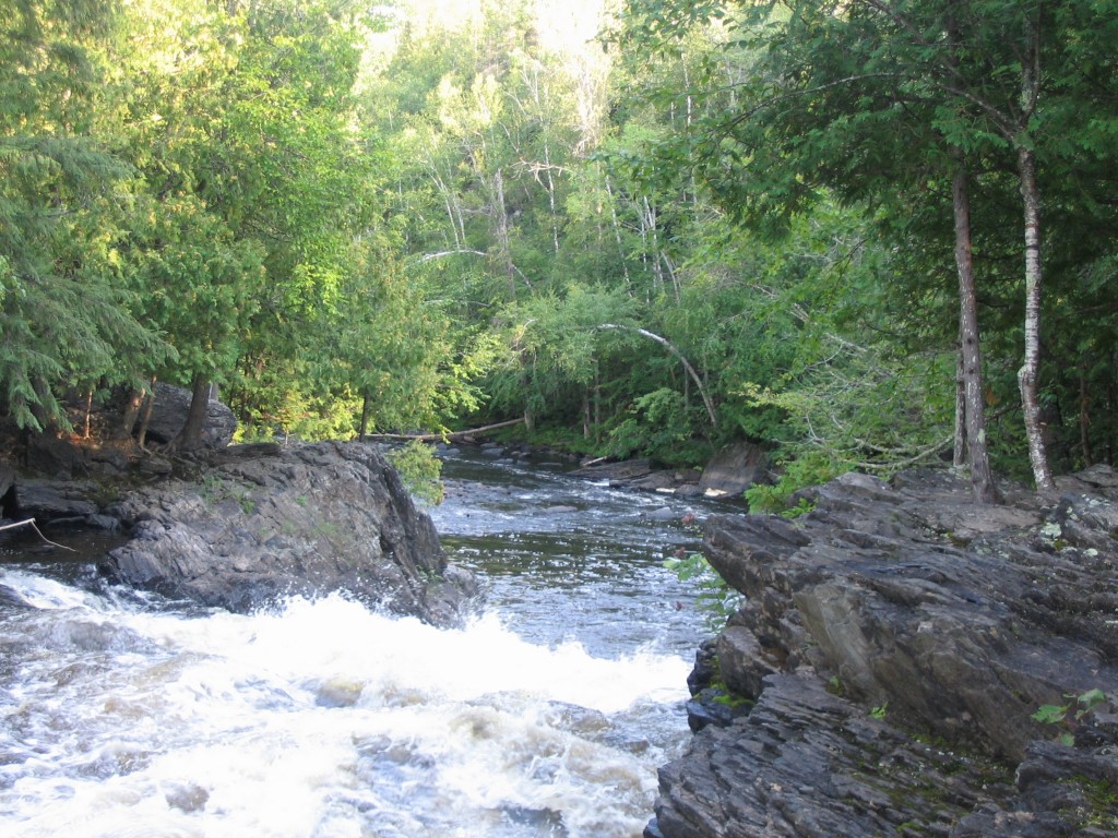
Although we walked up and down some ridges, the trend of the trail was climbing steadily higher. There was one point about an 1/8 mile from the falls that the roar of the falls was loudest. I believe this location was directly opposite the falls above the spot where the suspicious figure is visible in the photograph in question. At the next opportunity we found where we could leave the portage trail and approach the cliffs, we saw that we were standing along the edge of the rapids upstream from LaSalle Falls. The portage trail itself continued west to a safe put-out location upstream. This is where I found the scene that matches the photograph in question (see attached photograph labelled LaSalleFalls_Aug06_6.jpg).
Having finally achieved my #1 research goal for this trip, I told my family what I was going to do next. I took out the printed copy of the photograph in question, and my wife could see the location where the dark figure appeared to be standing downstream from the falls. I handed her one of the walkie-talkies and I took the other. She had our digital camera and the binoculars. I was wearing a bright orange T-shirt (I was thinking ahead about what I could do to be the most visible). While my wife and kids remained at the top of LaSalle Falls watching downstream to watch for any glimpse of my orange shirt, I would hike back down the portage trail and try to look for anyplace I could get closer to the edge of the cliffs overlooking the gorge. We would use the walkie-talkies to confirm when they could see me, and I would try to work my way down to where the dark figure was seen. In this way, I thought they could guide me to the correct location and take a comparison photograph of me standing there.
We spent the next half an hour while I poked around the edge of the cliffs. At one point, I had pushed myself around dead pine trees lining the top of the cliffs and descended about 15 feet into the gorge above an area where I could look down and see birch trees curving out over the valley- - but they never saw a glimpse of me in my orange shirt. The descents from ledge to ledge were taller than me and I didn't want to lower myself down someplace I couldn't get back from. I never found a way to descend any further over the edge of the cliffs until I was all the way back at the bluff overlook adjacent to the downstream end of the portage trail. At this location, I found that by turning around, facing the cliff, and using tree trunks and roots as handholds and working my way down about 5 feet at a time-- I was able to scramble down to the edge of the rapids down in the gorge. However, I could see no safe way to work my way up the edge of the river even though the water level was down this time of year. So I radioed my wife that I was down at the river's edge, but would climb back up and come back in her direction.
By this time, my wife and kids had seen enough of the falls and gorge so they wanted to leave and start heading my direction on the portage trail. We met somewhere around the middle and hiked back to the car uneventfully. My wife later told me that my second oldest daughter had found a clump of short grey hair while they were waiting at the top of the falls. However, she held it up and let it drop in the breeze and the clump of hair fell into the rapids. As a scientist, she thought such physical evidence might have been an important sample to collect. Judging by its length, color and appearance, she agreed with me that it more likely to have been fur of canine origin (that is, a wolf, coyote or fox).
CONCLUSIONS: I gained a much more intimate understanding of LaSalle Falls and the gorge vicinity in this visit. Subsequent analysis of greatly enlarged copies of the comparison photograph do reveal a dark black shape behind the summer foilage that matches the shape of the mysterious figure being seen in the original photograph. THEREFORE, we now suspect that the dark black shape is a pegmatite rock formation similar to the rocks found at the top of LaSalle Falls. Although an expedition down the cliffs into the Pine River gorge would be the only way to confirm this conclusion, the appearance of the same dark shape in both photographs is enough to convince us that the mysterious figure is an inanimate object. This is the best explanation for what is being observed in both pictures.
Respectfully submitted, David Gay, Staff Investigator Squatchdetective Organization
David also sent this: Autumn, Please feel free to use any or all of my 7-page investigation report It has previously been posted online at a link on Steve Kull's SquatchDetective web site. Also attached are documentation of the local weather conditions on the date of Rosick's photo, a detail topographic map of the location and two photographs described in my investigation report. (LaSalleFalls_Aug06_3 shows a white birch branch wedged among the pine trees southeast of the downriver end of the portage trail which seems suspicious and out of place. This was the only "squatchy" thing I found during my on-site investigation.) I originally discovered the Rosick photo in a discussion thread at the Unexplained Mysteries forum (see http://www.unexplained-mysteries.com/forum/index.php?showtopic=60145&st=0). You will see my postings on that forum (and everywhere else on the Internet) under the user account name, escAPEe. The skeptics thought that the dark "figure" was PhotoShopped into the photo as a hoax-- but when we obtained and confirmed its appearance in the film negative I knew I had to visit the location for further investigation.
Before visiting the site of Rosick's photograph, I expected I would be able to hike to the spot where the dark "figure" appears to be standing. The November 6, 2002 photograph gives the illusion of trails on the bank beyond the waterfall. LaSalle Falls on the Pine River turns out to be a 20+ foot dome waterfall into a deep gorge with nearly vertical cliffs. All the photographs taken by visitors are from the vantage point of Rosick's photo because not the gorge is inaccessible unless you repel down into it. Except for one video clip made by kayaking enthusiasts who rode over the falls during the spring snow melt (see the link in my investigation report), these falls are never seen from down inside the gorge. The Pine River cuts through the pegmatite rock layer at the head of LaSalle Falls down into a lighter colored granite formation seen in the background of Rosick's photo. Slabs of the black pegmatite line the upper levels of the gorge. The comparison photo I took in August 2006 (attached as LaSalleFalls_Aug06_6) reveals a black rock behind the foliage at the same location where the dark "figure" appears in Rosick's photo. Here are the photos David refers to:
[Edited 9/14/09 to add: Jason Pratt sent me a Word document with his analysis. You can download it here.]